 Magnetic field models
spaceweb@oulu.fi - last update: 11 May 1998, 1840 UT (RR)
The magnetic field of the Earth has been investigated by
satellites for several decades now, and enough of it is known to model its average
strength and shape during different levels of overall magnetic activity.
Presently the most used empirical global magnetic field models are the
Tsyganenko models
(1987, 1989), referred to as T87 and T89, respectively, although even these consist of
several submodels.
Later models include T95 and T96_01 (Tsyganenko, 1995; Tsyganenko and Stern, 1996).
All the realistic models start from the official International Geomagnetic Reference
Field (IGRF) model, which is improved by adding magnetospheric current systems that
modify it towards the true, observed configuration. Zhou et al. (1997) recently
tested the T96_01 version, and found major discrepancies with the observed field
only close to the cusp.
Other models include Olson and Pfitzer (1974), Mead and Fairfield (1975),
Alexeev et al. (1996), and Ostapenko and Maltsev (1997).
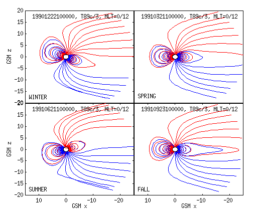
One useful application of a magnetic field model is that you can trace a field
line from a given point, creating thus a map of the Earth's
magnetosphere.
In the series of figures below, the magnetospheric topology is seen to be dependent
on the season. The model used is the T89c, and the Kp index
is taken to be 2.
 |
|
Earth's magnetic field from T89c model during Kp=2 for different seasons.
|
The problem with this kind of global models is that they work poorly for specific
event studies. Because of this, local magnetic field models have been created
using simultaneous magnetic observations from a number of spacecrafts (Sergeev et al.,
1990; Pulkkinen et al., 1991, 1992).
Still another way to model the true magnetic field configuration is to probe
magnetic field gradients via the remote sensing of the magnetic field by
low-altitude spacecraft, as has been done using the isotropic
boundary algorithm (Sergeev and Malkov, 1988; Sergeev et al., 1993).
References
- Alexeev, I. I., E. S. Belenkaya, V. V. Kalegaev, Y. I. Feldstein, and A. Grafe,
Magnetic storms and magnetotail currents, J. Geophys. Res., 101,
7737-7747, 1996.
- Mead, G. D. and D. H. Fairfield, A quantitative magneto-spheric
model derived from spacecraft magnetometer data,
J. Geophys. Res., 80, 523-534, 1975.
- Olson and Pfitzer, J. Geophys. Res., 79, 3739-, 1974.
- Ostapenko, A. A., and Y. P. Maltsev, Relation of the magnetic field in
the magnetosphere to geomagnetic and solar wind activity,
J. Geophys. Res., 102, 17467-14473, 1997.
- Pulkkinen, T. I., D. N. Baker, D. H. Fairfield, R. J. Pellinen, J. S. Murphree,
R. D. Elphinstone, R. L. McPherron, J. F. Fennell, and R. E. Lopez,
Modeling the growth phase of a substorm using the Tsyganenko model and multi-spacecraft
observations: CDAW-9, Geophys. Res. Lett., 18, 1963-, 1991.
- Pulkkinen, T. I., D. N. Baker, R. J. Pellinen, J. Buchner, H. E. J. Koskinen,
R. E. Lopez, R. L. Dyson, and L. A. Frank, Particle scattering and current sheet
stability in the geomagnetic tail during the substorm growth phase,
J. Geophys. Res., 97, 19283-, 1992.
- Sergeev, V. A. and M. Malkov, Diagnostics of the magnetic configuration of the
plasma layer from measurements of energetic electrons above the ionosphere,
Geomagn. Aeron., 28, 549-, 1988.
- Sergeev, V. A., M. Malkov, and K. Mursula, Testing the isotropic boundary
algorithm method to evaluate the magnetic field configuration in the tail,
J. Geophys. Res., 98, 7609-7620, 1993.
- Sergeev, P. Tanskanen, K. Mursula, A. Korth, and R. C. Elphic, Current sheet
thickness in the near-Earth plasma sheet during substorm growth phase,
J. Geophys. Res., 95, 3819, 1990.
- Tsyganenko, N. A., Global quantitative models of the geomagnetic field in the
cislunar magnetosphere for different disturbance levels
Planet. Space Sci., 35, 1347-1358, 1987.
- Tsyganenko, N. A., A magnetospheric magnetic field model with a warped tail
current sheet, Planet. Space Sci., 37, 5-20, 1989.
- Tsyganenko, N. A., Modeling the Earth's magnetospheric magnetic field confined
within a realistic magnetopause, J. Geophys. Res., 100, 5599-5612, 1995.
- Tsyganenko, N. A., and D. P. Stern, Modeling the global magnetic field of the
large-scale Birkeland current systems, J. Geophys. Res., 101, 27187-27198, 1996.
- Zhou, X.-W., C. T. Russell, G. Le, and N. Tsyganenko, Comparison of observed
and model magnetic fields at high altitudes above the polar cap: POLAR
initial results, Geophys. Res. Lett., 24, 1451-1454, 1997.
See also:
 Magnetic field models
 Magnetic field models