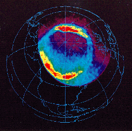
 Auroral ovals
 Auroral ovals
 Geographically, most auroras are located within oval
shaped regions around both geomagnetic poles of the
Earth (however, see also
sun-aligned arcs).
Although the existense of these auroral ovals was
derived from the early ground-based observations, they
were imaged for the first time by the Dynamic Explorer 1
satellite (DE-1) in the early 1980's (the figure here is
from Polar UltraViolet Imager: foreground is dayside!).
The ovals are displaced relatively to the magnetic poles
such that they extend further towards equator at the
midnight sector.
The regions that are left inside the ovals are called the polar caps. While the magnetic field lines within the polar caps are open, i.e., they are connected to Earth only on one end, the field lines inside the oval (and at lower latitudes) are closed. Because of this, the auroras on northern and southern oval region can be mirror images of each other. The diameter of the ovals depends on the amount of the open flux in the polar cap: during active periods, especially during major geomagnetic storms, the ovals expand to lower latitudes.
Although the latitudinal width of the oval is rather small (about 10°), it maps, in the nightside, to a spatially vast region in the plasma sheet and plasma sheet boundary layer (PSBL). The enhanced activity in the upper part of the figure corresponds to a nightside substorm. This can lead to a formation of a double oval structure at the last stage of the substorm activity or during the recovery phase (Elphinstone et al., 1994). At the same time the figure shows how intense the dayside auroras can be.
Low- and mid-altitude, polar orbiting satellites crossing the oval regions encounter, e.g.,
See also: